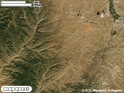
Beaver Hollow Cooperative Wildlife Management Unit (CWMU) is just east of the right extension of Lost Creek Reservoir. The CWMU is cut by Francis Canyon from the northeast to the west. The elevation range for Francis Canyon as it enters and exits the Unit is 7000 feet to 6200 feet, east to west. Elevation ranges from 7600 feet to 6100 feet on the Unit. Besides being cut by Francis Canyon, the Beaver Hollow CWMU is cut by the South Fork of Francis Canyon, Beaver Dam, Long Hollow and Red Hollow. The most common elevation is 7200 feet but ranges from 6100 feet to 7700 feet with an elevation difference of 1600 feet. Fifty-seven percent (57%) of the CWMU elevation ranges between 6500 feet and 7200 feet an elevation difference of 700 feet.The dominate land cover type on the Beaver Hollow Cooperative Wildlife Management Unit (CWMU) is the Inter-Mountain Basins Montane Sagebrush Steppe (62). Towards the northeast corner are extensive areas of Recently Burned (116) land cover. Distributed among the Sagebrush Steppe are patches of Rocky Mountain Gambel Oak-Mixed Montane Shrubland (41) and Rocky Mountain Aspen Forest and Woodland (22).One of the Beaver Hollow Cooperative Wildlife Mangement Unit (CWMU) nearest weather stations, ECHO DAM (422385), is about 21.5 km northeast from the northeast edge of the CWMU. ECHO DAM has sixty-seven (67) years of records, 1940 - 2007. During the FALL (September, October and November) the average precipitation is 3.88 inches, but it can be as high as 10.59 inches or as low as 0.47 inch. During the 91-day FALL period, 21 days will experience greater than or equal to 0.01 inch of precipitation, 11 days of greater than or equal to 0.10 inch, or 2 days of the greater than or equal to 0.50 inch of precipitation. Snowfall during the FALL averages 12.1 inches but can be as high as 41.5 inches. FALL temperature at ECHO averages 46.5 degrees F. but can be as high as 97.0 degrees F. or as low as -21.0 degrees F. During the FALL, 54 days will be below freezing (32 degrees F.) and 3 days above 90 degrees F.