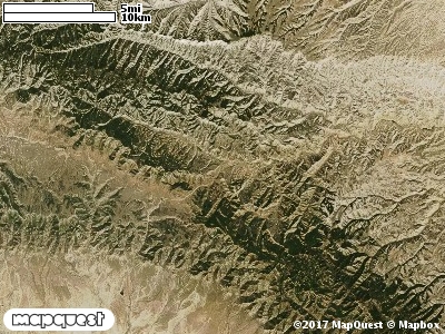
The Minnie Maud Ridge Cooperative Wildlife Management Unit (CWMU) is located northeast of Helper, Utah on the Duchesne - Carbon County border. The Minnie Maud Ridge ranging from 8800 feet in the northwest to 8200 feet on the east side forms the higher elevations on this Unit. The Roan Cliffs (8400 feet) slopes away from the Ridge forming the southern boundary. To the north Minnie Maud Creek cuts the unit and in some places forms the northern boundary ranging from 8400 feet in the west to 6900 feet in the east. The eastside of the Unit runs into Ninemile Canyon. Eight drainages cut the Unit in the north and seven drainages cut the Unit in the south. The most common elevation is 8200 feet but ranges from 7000 feet to 9200 feet with an elevation difference of 2200 feet. Fifty-three percent (53%) of the CWMU elevation ranges between 7700 feet and 8400 feet an elevation difference of 700 feet.
The Minnie Maud Ridge Cooperative Wildlife Management Unit (CWMU) is dominated by a combination of two (2) land cover types in about equal proportions, Inter-Mountain Basins Montane Sagebrush Steppe (62) and Rocky Mountain Aspen Forest and Woodland (22). Rocky Mountain Gambel Oak-Mixed Montane Shrubland (41) is scattered in patches throughout the Unit. Colorado Plateau Pinyon-Juniper Woodland (36) is confined to the northwest part. There are some large patches of Rocky Mountain Montane Dry-Mesic Mixed
Conifer Forest and Woodland (30) and Inter-Mountain West Aspen-Mixed Conifer Forest and Woodland Complex (38) towards the middle-west of the Unit.
One of the Minnie Mouse Ridge Cooperative Wildlife Mangement Unit (CWMU) nearest weather stations, PRICE BLM (427026), is 22.9 km southwest of the southwest edge of the CWMU. PRICE BLM has forty (40) years of records, 1968 - 2008. During the FALL (September, October and November) the average precipitation is 2.87 inches, but it can be as high as 6.48 inches or as low as 0.44 inch. During the 91-day FALL period, 13 days will experience greater than or equal to 0.01 inch of precipitation, 7 days of greater than or equal to 0.10 inch, or 2 days of the greater than or equal to 0.50 inch of precipitation. Snowfall during the FALL averages 1.8 inches but can be as high as 7.8 inches. FALL temperature at PRICE BLM averages 33.4 degrees F. but can be as high as 95.0 degrees F. or as low as 4.0 degrees F. During the FALL, 27 days will be below freezing (32 degrees F.) and no day above 90 degrees F.