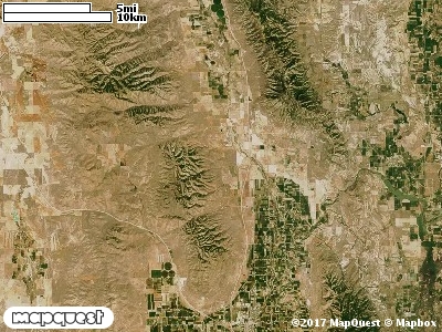
The West Hills Cooperative Wildlife Management Unit (CWMU) is located west of Fielding, Utah southwest of Plymouth, Utah and northwest of Garland, Utah on what is called the West Hills. Higher elevations run north and south, mostly in the middle of the Unit. In the north the higher elevations are around 6500 feet, rising to 6800 feet in the middle, then decreasing to about 6100 feet in the south. Most of the major drainages flow west to east on the eastside of the Unit. Marlow Canyon (5500 feet to 6300 feet) is in the north. Butler Canyon is larger (4600 feet to 6200 feet) and is the next drainage to the south. Topance Canyon (4600 feet to 6800 feet) which starts at the end of Magpie Springs
Canyon and flows east almost cuts the Unit in half. The prominent drainage on the westside of the Unit is Blind Spring Canyon, ranging from 4900 feet to 5800 feet. The most common elevation is 5700 feet but ranges from 4400 feet to 6800 feet with an elevation difference of 2400 feet. Fifty-three percent (53%) of the CWMU elevation ranges between 5100 feet and 6000 feet an elevation difference of 900 feet. Around forty percent (40%) of the West Hills Cooperative Wildlife Management Unit (CWMU) is
Inter-Mountain Basins Big Sagebrush Shrubland (48). Mixed among this Sagebrush Shrubland is Rocky Mountain Bigtooth Maple Ravine Woodland (23) and Great Basin Pinyon-Juniper Woodland (37). On the eastside are extensive areas of Agriculture (114). There are
also areas of Inter-Mountain Basins Semi-Desert Grassland (76), Invasive Annual Grassland (121) and Southern Rocky Mountain Montane-Subalpine Grassland (71) that add to the grassland character of the area.One of the West Hills Cooperative Wildlife Mangement Unit (CWMU) nearest weather stations, GARLAND (423122), is 3.1 km east of the east edge of the CWMU. GARLAND has seventy (70) years of records, 1909 - 1979. During the FALL (September, October and November) the average precipitation is 3.79 inches, but it can be as high as 7.08 inches or as low as 0.83 inch. During the 91-day FALL period, 17 days will experience greater than or equal to 0.01 inch of precipitation, 10 days of greater than or equal to 0.10 inch, or 2 days of the greater than or equal to 0.50 inch of precipitation. Snowfall during the FALL averages 3.1inches but can be as high as 14.0 inches. FALL temperature at GARLAND averages 49.4 degrees F. but can be as high as 109.0 degrees F. or as low as -13.0 degrees F. During the FALL, 36 days will be below freezing (32 degrees F.) and 2 days above 90 degrees F.