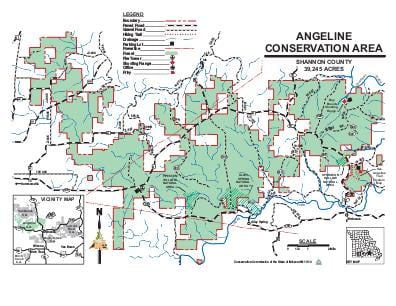
Driving DirectionsNorth of Eminence and extending 15 miles west towards Summersville. Enter from Highways 19 and 106 or Route D.
HighlightsThis rugged forest and old fields area has a hiking trail and 25 miles of field roads open to horseback riders. It also offers access to the Jacks Fork and Current rivers.
About This AreaThe Angeline Conservation Area lies north of the Jacks Fork and west of the Current River. The 39,590-acre area is north of Eminence and extends 15 miles west to near Summersville, accessed by Highways 19 and 106 or Route D.Numerous small springs, seeps and sinkholes are found on the area due to the karst topography.Clow, Alley Spring and Flat Rock conservation areas and the Kerr-McGee purchase were combined to create this single conservation area. Angeline takes the name of a small logging camp found in the area during the 1920s. The camp was part of the Missouri and Mining Mill, located in West Eminence, in operation from 1909 to 1927. The area reached its peak population with the logging boom of the early 1900s.Points of interest include a scenic overlook on Highway 19, the headquarters for the Eminence forestry district office, Bay Creek Shooting Range, Flat Rock Lookout Tower, Lick Log Hollow Nature Trail a one mile interpretive hike and a day use Equestrian loop trail system that is 9.5 miles long.