Driving DirectionsFrom Bland, take Route A north about 1.20 miles, then east on the area's southern most access road (the road north of Rehmert Road).North access is on Highway A north an additional 1.70 miles, then east on Boettcher Road 1.50 miles.
HighlightsThis area is mostly forest. Facilities/features: primitive camping, two intermittent streams, a multi-use trail, and two small ponds (one acre total).
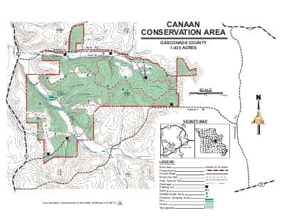
About This AreaCanaan Conservation Area is located in Gasconade County, near Bland. Take Route A about 1.2 miles north from Bland to the Conservation Area's southern most access road. A sign on Route A shows the turn to the east; or stay on Route A an additional 1.7 miles to the north past this turn to Boettcher Road. Go east on Boettcher Road 1.5 miles to main entrance on right. The area has six parking areas.The Conservation Department purchased this property in 1980. Canaan Conservation Area contains 1,435 acres, 77 percent of which are forested or woodland and glade. The area includes 1.4 miles of Clear Fork Creek, 1.2 miles of Sulphur Branch Creek, several small springs, and a deep muck fen. The area also features a scenic north-facing slope adjacent to Sulphur Branch and a glade/woodland complex.The first inhabitants of the area were nomadic Indians, who hunted here. Through the efforts of the German Resettlement Society, German immigrants then settled here and began working farms in the 1800s.The conservation area is composed of two of these working farms. The Conservation Department continues to crop a portion of the area. The Department also maintains the warm-season grasses, the deep muck fen, and the woodland/glade complex.In 2008 the Department opened a multi-use trail that is open to hikers, bicycles and horseback riding. This trail is 10.4 miles long with three complete loops. Signs of natural community restoration work can be seen where cedar and hardwood trees have been cut to enhance the structure of the area's woodlands.