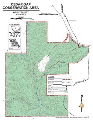
Driving DirectionsFrom Mansfield, take Highwy 60 west 4 miles, then Route O south 0.75 mile to the end of the pavement, continue on gravel road 0.25 mile to parking lot.
HighlightsThis is a forest area at the headwaters of Bryant Creek.
About This AreaCedar Gap CA came into existence in 1999 thanks in large part to the dedication and commitment of a small group of private citizens from Springfield and the local community of Cedar Gap.The Cedar Gap Plateau is recognized as the second highest point in the State of Missouri. From this large plateau, three large watersheds begin: Gasconade River, Finley River, and Bryant Creek.At Cedar Gap CA, visitors can explore the headwaters of Bryant Creek, view limestone glades, and explore the oak/hickory forest. A gravel-surfaced trail leads from the parking lot to a valley overlook. This three-eighths mile trail can accommodate most hikers with some effort. For a more rugged hike, visitors can continue beyond the overlook and hike the 1.6 mile loop trail. While hiking or exploring, visitors will notice the remnants of a limestone quarry and limestone glades.Management practices on the glades are conducted periodically to stimulate native plants and flowers, and to improve collared lizard habitat.During most of the year, Bryant Creek is a peaceful bubbling brook. In periods of heavy rainfall, visitors should use caution when crossing the stream.