Driving DirectionsIn North St. Louis County, take the Riverview Drive exit from I-270, then Riverview north about 2.50 miles to the area.
HighlightsThis area contains cropland, forest, wetlands, and old fields. There is a visitor center and office along with hiking and biking trails, interpretive sites and a boat ramp to the Missouri River. The unique feature of this area is the confluence of the Missouri and Mississippi rivers, which can be seen from a viewing deck.
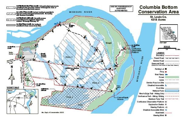
About This AreaColumbia Bottom Conservation Area is in north St. Louis County at the confluence of the Missouri and Mississippi rivers.The Conservation Department purchased this 4,318-acre area in 1997 to create an urban conservation area. The area includes a view of the confluence of the Missouri and Mississippi rivers, more than 6.5 miles of river frontage, about 800 acres of bottomland forest and a 110-acre island.A small town once known as Columbia and later St. Vrain, was located in this river bottom. It was shown on plat maps from the mid 1800s, but was gone by 1870.A flood protection levee protects most of this bottom from minor floods. The great flood of 1993 overtopped this levee and flooded most of the area, depositing sand, and debris. The area will continue to be prone to occasional flooding.The Conservation Department is managing Columbia Bottom to create a mosaic of bottomland habitats that includes shallow wetlands, bottomland hardwoods, prairie, and cropland. These habitats attract a wide variety of resident and migratory wildlife for the enjoyment of all of our state's residents and visitors.Public access facilities, including roads, trails, a river access and a viewing area at the confluence were constructed in 2002. A Visitor Center and a series of Exploration Stations were completed in 2004.