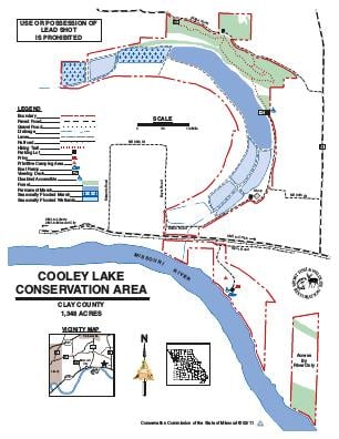
Driving DirectionsFrom Missouri City, take Highway 210 east 2.50 miles to the area.
HighlightsThis 1,348-acre area includes an ancient oxbow lake (Cooley Lake), which was once the main channel of the Missouri River, and also wetlands, croplands, and a forested bluff.Frequent drying of Cooley Lake inhibits quality fishing. The area also has access to the Missouri River.Facilities/features: Disabled accessible boat ramp and privy are available on the Missouri River. An observation deck overlooking the oxbow lake feature is located on the portion of the area which lies north of Highway 210. A viewing platform is also located along Ridge Road overlooking the historic Missouri River oxbow and its floodplain.