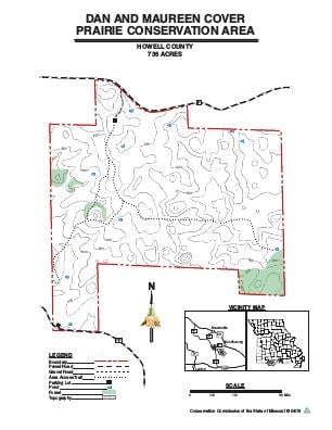
Driving DirectionsFrom West Plains, take Highway 63 south to Koshkonong, take Route F west 3 miles to Cover Prairie on the south side of Route F.
HighlightsThe area is located on a large sinkhole plain and includes several large sinkholes. Species associated with these sinkholes include yellow lady's slipper, Turk's cap lily, and the state-listed royal catchfly.There are two parking lots that serve the area: one off Route F and the other off of Route PP located on the south side of the area. There are no other facilities.
About This AreaCover Prairie Conservation Area is in southeast Howell County, about three miles east of Koshkonong, off of Route F.About 60 percent of the area is dominated by grass herbaceous cover. The remaining open land is a mixture of hardwood shrubs and soft mast, such as blackberry bushes. A small portion of the area is covered by dry-mesic chert woodland with the predominant tree species being blackjack, post oak, and hickory.Cover Prairie Conservation Area is characterized as a heavy karst field with many sinkholes. All of the surface water flows either into local sinkholes or runs into the Grand Gulf and re-emerges at Mammoth Spring, Arkansas.Dan Cover purchased the land in 1988, before which the area had been cleared and used for raising swine. After Mr. Cover acquired this property, he created an early successional community through the use of prescribed fire, warm-season grass plantings, and removal of exotic plant species. In 2001, Dan Cover donated this property to the Missouri Department of Conservation because he was confident the MDC would continue his efforts to manage the landscape for wildlife.Area facilities include two parking lots.