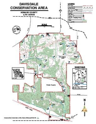
Driving DirectionsFrom Columbia, take I-70 west, take Highway 40 west 12 miles and watch for area sign.
HighlightsThis area is more than half forest. It also contains loess hills, cropland, old fields, grassland and prairie. Facilities/features: primitive camping and 16 fishable ponds (17.5 acres total).
About This AreaDavisdale Conservation Area is in Howard County, 15 miles west of Columbia and seven miles east of Boonville on Highway 40. This 2,701-acre area features over 800 acres of riverhills woodland, which includes pecan and walnut, large tracts of warm- and cool-season grasses, interspersed with old fields, legumes and shrubs. A variety of crops are planted in rotation on about 300 acres of the area. Grain is left unharvested as winter food for wildlife. The area contains at least three Indian mounds. Davisdale features a series of scenic limestone bluffs carved by the Missouri River, which now flows 1.5 miles away. Before its purchase by the Conservation Department in 1981, Davisdale was one of the larger single-family holdings in Howard County. It was actually a collection of several small farms, with more than a dozen homes. Bricks for some of the structures were cast from clay mined on the area.The early English settlers maintained livestock and planted wheat, oats and corn, as well as tobacco, in the deep loess soils. At one time, Howard County led the state in tobacco production. Soil conservation practices, including contour terraces, catch basins, limited tillage and crop rotation, instituted by the early settlers are still practiced today. Legumes and native grasses are planted to control erosion and replace less desirable grasses, such as tall fescue.