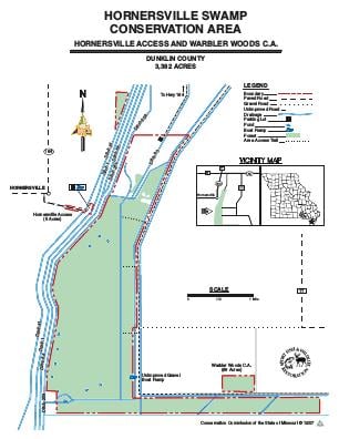
Driving DirectionsFrom Rives, take Highway 164 west approximately 3 miles, then County Road 701 south to the area.
HighlightsThis is a mostly bottomland forest area with cropland and wetlands. Facilities/features: boat ramp and five floodways.
About This AreaHornersville Swamp Conservation Area is in southernmost Dunklin County, two miles southeast of Hornersville.This conservation area provides an excellent example of how the entire vicinity appeared before drainage and clearing changed the face of Missouri's Bootheel. The 3,166-acre area is a remnant of 2.4 million acres of bottomland hardwoods that once encompassed all of Dunklin, Pemiscot, Stoddard, New Madrid, and Mississippi counties.The area is 80 percent forestland with the dominant trees being typical bottomland species. Overcup oak, green ash, and cypress are present in the very lowest areas while Nuttall oak, willow oak, water oak, pin oak, and hickory trees inhabit the slightly higher sites. The lowest elevation in Missouri, 230 feet mean (average) sea level, is found on the south end of the area.Hornersville Swamp Conservation Area is adjacent to the Big Lake National Wildlife Refuge in Arkansas. Hence, together these areas provide nearly 20,000 acres of wildlife habitat. Deer, raccoons, squirrels, and other forest inhabitants are plentiful, and when the area is flooded, mallards, and wood ducks feed heavily on pin oak acorns.Management of the area is designed to protect and enhance one of the few remnants of bottomland hardwood timber in the Bootheel with special emphasis on providing habitat for migratory wintering mallards.Over 600 acres of the area were heavily logged prior to 1980, and this portion is undergoing corrective measures to provide the desired tree composition.Water management on Hornersville presents unique problems, because the area is at the end of floodway ditches and can flood overnight. Public use is prohibited except fishing and waterfowl hunting by boat only when the water level is at or above 239 feet on the Hornersville Gauge at the boat ramp.There are 400 acres of open fields on the area that are managed through sharecropping agreements with local farmers to provide food throughout the fall, winter, and early spring. Milo is the dominant cereal grain in the large fields. The smaller open fields are disced to encourage the growth of wild foods such as wild millet, smartweed, ragweed, and pigweed. This overall management approach makes a diversity of food available to wildlife throughout the year.