Driving DirectionsFrom Salem, take Highway 19 northeast 12 miles to the area.
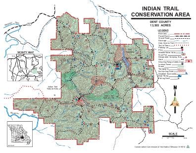
HighlightsThis large area is primarily forest. Facilities/features: primitive camping, Blackwell Lake (35 acres), picnic area, numerous small ponds, two permanent streams (Fishwater Creek, Crooked Creek).
About This AreaIndian Trail Conservation Area covers 13,503 acres in northeast Dent County, between Salem and Steelville. The entrance to the area is off Highway 19.The area is mostly forested, but also includes food plots, ponds.The area contains an intricate mosaic of dolomite glades and chert savannas with open-grown trees on exposed slopes. The canopy of the slopes is dominated by post, black, white, and blackjack oaks and hickories. The ground cover of the glades and savannas includes little bluestem, big bluestem, sideoats, grama and Indian grasses and wildflowers, such as white and purple prairie clovers and pale purple coneflower. Dolomite bedrock outcrops and ledges are scattered throughout the glades.Formerly, the area was the site of the Sligo Iron Company. Heavy cutting of cordwood to fuel the smelters depleted local timber supplies, eventually forcing the iron works to close.Private owners acquired the Indian Trail area in 1906 for use as rangeland. Grazing and burning to encourage grass growth continued until the state purchased the tracts comprising the area from 1924 to 1927, largely in an effort to control wildfires.One route of the Trail of Tears went through Indian Trail Conservation Area. Markers and a plaque depict the Indians' trail and describes their ordeal.From 1930 until 1960, the area served as a game refuge, providing deer and turkey for the state's restocking programs.Civilian Conservation Corps crews, based at the area from 1933 to 1946, built most of the area's 55 miles of access roads, constructed the pond and planted pine trees in many of the open areas.During your visit to Indian Trail Conservation Area, you may view various forest improvement practices designed to improve wildlife habitat, maintain watershed quality and enhance tree growth, quality, and species composition. Any change in forest and woodland structure is temporary as removed vegetation is quickly replaced by vigorous growth.