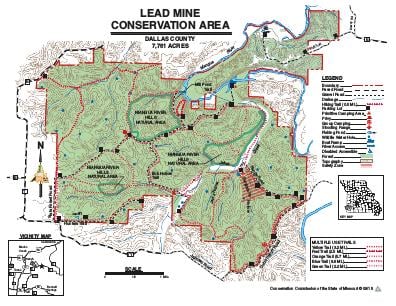
Driving DirectionsSouthwest entrance: From Plad, take Highway 64 west, then Route T north, then Route YY east 0.50 mile. Northeast entrance: From Lebanon, take Highway 5 north to Route E, which will become Bluff Trail at the end of pavement. Follow Bluff Trail 0.25 mile to area. There is no vehicle access to the west side of area from the east side.
HighlightsThis forested area contains savanna, glades, and old fields. Facilities and features include boat ramps, an unmanned firearms range, fishable ponds, several intermittent streams, and two permanent streams (Niangua River, Jakes Creek).
About This AreaLead Mine Conservation Area is in northeastern Dallas County, 40 miles south of Lake of the Ozarks, 12 miles north of Bennett Springs, five miles east of Tunas, and 21 miles northeast of Buffalo.The area provides about two miles of Niangua River frontage and has a 3.5-mile stretch of Jakes Creek running through it. The area also has several wildlife watering ponds and seven springs and is composed mainly of forest land.The Conservation Department purchased the original 600 acres for the Lead Mine Conservation Area in 1965 through a University of Missouri land grant. Additional land was acquired with Pittman-Robertson and Dingell-Johnson funding, and the state conservation sales tax, increasing the area to 7,761 acres.During early settlement in the late 1800s and early 1900s, some lead mining did take place near the area. However, evidence of this is hard to find.Many people made their living and raised their families on small farms that now make up Lead Mine Conservation Area. The town of Lead Mine, just one-quarter mile west, is a small community known for its country atmosphere, hand-made goods and horse drawn buggies.Lead Mine Conservation Area contains many excellent examples of dolomite glade communities, oak-hickory uplands, and clear running springs. Deer, turkey, raccoon, squirrel, rabbit, coyote, and many other small animals and birds are commonly seen from the gravel roads and forest trails.Wildlife habitat management includes the creation of watering ponds and manipulation of fields within the forest to provide added food sources. Timber harvesting is also an important element in habitat management. It produces forage and cover for forest wildlife.There are five primitive camping areas. One is for groups by special use permit only and one is only open October 1 through January 15. The main campground has 51 sites with 26 of them able to accommodate trailers. Camping is all on a first come first served basis.