Driving DirectionsFrom Bloomsdale, take Highway 61 south, then Route V east 1 mile, then White Sands County Gravel Road north to the area.
HighlightsThis is a forest area with some old fields. Facilities/features: skeet range, archery range, and a permanent stream (Establishment Creek).
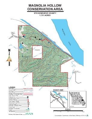
About This AreaMagnolia Hollow Conservation Area is in Ste. Genevieve County, 10 miles north of Ste. Genevieve along the Mississippi River.This rugged 1,740-acre area is bordered by Establishment Creek and Schmidt's Island, along-side the Mississippi River. The area features steep bluffs and scenic river views. Eagles are commonly sighted along the river.The forest at Magnolia Hollow Conservation Area is diverse, ranging from mixed hardwoods to cedar glades. Magnolia Hollow, itself, is a deep draw, containing a wide variety of trees, shrubs, herbs and wildflowers, including begonia orchids.Wildlife management practices in forest include creating watering ponds, planting fields to serve as food sources for animals, and harvesting timber, which provides improved forage and cover for wildlife.Management of Magnolia Hollow and Establishment Creek corridors is minimal and is designed to protect the steep and sensitive watersheds.A disabled accessible viewing platform is available for observing the Mississippi River and Establishment Creek bottoms.