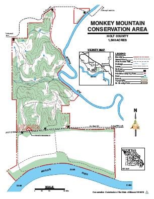
Driving DirectionsFrom I-29 Exit 67 north of St. Joseph, take Highway 59 west 4 miles, then Route U south 3.50 miles to the area sign, and County Road 325 east for about 1 mile.
HighlightsThis area has 800 acres of mostly forested bluffs above the Missouri River and 780 acres of Missouri River floodplain. This area also has stream frontage along the Missouri and Nodaway Rivers.
About This AreaMonkey Mountain Conservation Area is in Holt County, northwest of St. Joseph. The Conservation Department purchased this area in 1978 to provide public land for outdoor activities in northwest Missouri. The United States Army Corps of Engineers has purchased an additional 560 acres adjoining MDC's area, as part of the Missouri River Mitigation Project. The mitigation project has been designed to enhance fish and wildlife habitat along the Missouri River. The area is managed through a cooperative effort between the Corps of Engineers and the Missouri Department of Conservation.This area was called "Monkey Mountains," because early settlers deemed the river bluffs too steep for even monkeys to climb.The Lewis and Clark Expedition opened up this portion of the state for settlement, when it passed along the southern portion of the area on July 8, 1804. Settlement began on a large scale in 1836. At that time about 20 percent of the county, primarily the steep slopes, was in upland forest cover, consisting mainly of bur oak, white oak, red oak, black walnut, American elm, hickory and basswood. The remainder of the land, mostly ridge tops and rounded knolls, was either grassland or open timber with an understory of native grass.Monkey Mountain Conservation Area is managed for a wide range of game and non-game wildlife species. The area is available to the public for a variety of outdoor ativities. Management of the area includes farming, haying and prescribed burning, plus developing wildlife habitat by tree, shrub, and grass plantings and selective harvesting of timber.