Driving DirectionsPea Ridge Conservation Area consists of several tracts and is marked with a sign on Highway 185 between Sullivan and Potosi.
HighlightsThis area is mostly forest. It contains Hi Pointe Lake (two acres, fishable).
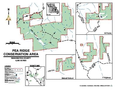
About This AreaPea Ridge Conservation Area is in Washington County. The area consists of four tracts of land, the largest of which straddles Highway 185, midway between Sullivan and Potosi. The 1,058-acre HiPointe tract is bisected by Pelican Ridge Road off of Route T. The 1,045-acre Route F Unit is accessed from Route F and Sugar Loaf Road, and the 720-acre Metcalf School Unit is accessed from Lodge Road off of Route W.The Conservation Department began purchasing land for the Pea Ridge Conservation Area in 1946 with the bulk of the main tract acquired in the 1970s. Pittman-Robertson funds allowed the purchase of 265 acres in 1978.At one time, the Jefferson City Trail ran through the main tract. The Rock Springs General Store and Post Office were once located on the trail.The forest is composed of oak, hickory, pine, and associated species. Cedar is found in glade areas, and bottomland hardwoods are found along streams.The main tract includes a fen, four springs, a sinkhole, a dolomite cliff, 10 dolomite glades, and over three miles of Indian Creek, an Ozark headwater stream.Moisture loving plants, such as hydrangea, common fragile fern, pawpaw, basswood, and wild ginger, grow at the base of the dolomite cliff. Drought-tolerant plants, such as little bluestem, side oats grama grass, Missouri black-eyed Susan and pale purple coneflower, grow on the dolomite glades.Visitors to the main area will find several primitive camping areas, six parking lots and five access roads.The HiPointe unit has a camping spot, three parking lots, and a two-acre fish pond.Management of the area includes establishing and maintaining water holes, old growth forest areas, riparian corridors, fields, savannas, glades, and forest.