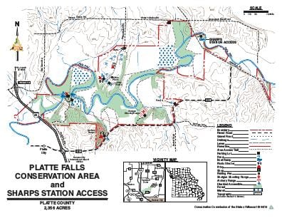
Driving DirectionsSouth side: Take Route HH (Platte City exit) east 0.60 mile. North side: Take the Highway 371 exit off I-29, travel northeast on Elm Grove Road about 1.50 miles, then east on Sharps Station Road 1.60 miles, and south on Settle Station Road 0.50 mile.
HighlightsThis area contains forest, cropland, old fields, and pasture. Facilities/features: boat ramps, pavilions, shotgun and archery ranges, fishable ponds (two acres total), and permanent stream (Platte River).
About This AreaThe Conservation Department purchased Platte Falls Wildlife Management Area in 1980 with funds from the 1/8 of 1% Design for Conservation sales tax. The 2,366-acre area includes 1320 acres of bottomland and upland timber, 295 acres of agricultural lands, 515 acres of grasslands and old fields, and 206 acres of wetlands. Hunting, fishing, hiking, canoeing, and birdwatching are popular here, and a 9.1-mile unchannelized stretch of the Platte River flowing through the area allows many river-oriented activities and recreations.The area has an archery sight-in range, as well as a shotgun range. Firearms firing single projectiles are prohibited on the shotgun range.