Driving DirectionsFrom Wayland, take Highway 27/61 south 7 miles, then Route F east 2.50 miles, then Route P north 2 miles, then on unnamed gravel road west 0.25 miles, then on unnamed gravel north 0.50 miles.
HighlightsPrimarily wetlands and old fields and a permanent stream (Honey Creek).
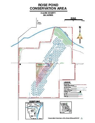
About This AreaThis 379-acre area consists mostly of bottomlands associated with Honey Creek, which empties into the Mississippi River. Approximately 38 acres are marshland. Rose Pond is believed to be a very small remnant of a once extensive marsh system associated with the mouth of the Des Moines River. A deep, sandy soil found here is assumed to have been deposited by the Des Moines River. Sand prairies were once found here and are now being restored. Rose Pond Conservation Area was purchased as critical habitat for several wetland species. The management emphasis encourages healthy populations of wetland wildlife and provides permanent emergency marsh habitat while offering the public compatible outdoor recreational opportunities. As part of the amphibian and reptile management regime, pooled water on the area is fishless. The best fishing opportunities lie within Honey Creek. Management techniques include construction of shallow water habitat, establishment of native prairie plant species, restoration of original soil hydrology, protection of wildlife in refuges and construction of critical wildlife habitat. The Conservation Department purchased the bulk of this property in 1983. In 1984, David and Charlotte Fox donated 27 acres, with the stipulation that it be designated a wildlife refuge. That request was granted.