Driving DirectionsFrom Osage City, take Engineer Road east 2 miles.
HighlightsThis is a forest area. Facilities/features: historic area (Dodds Island), two permanent streams (Missouri River, Osage River).
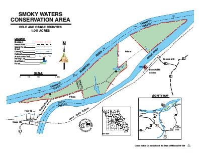
About This AreaSmoky Waters Conservation Area in Cole County is located on a peninsula formed by the confluence of the Missouri and Osage Rivers. To get there from Highway 50/63, east of Jefferson City, go north on Route J and proceed into Osage City. Turn east after crossing the railroad tracks and follow Engineer's Road out onto the peninsula. There are two public access parking lots in the 1,041 acre site.Historically, the peninsula was an island, known as Dodd's Island. Construction of the diversion levee by the Army Corps of Engineers linked the island to the mainland.The area is divided into two tracts separated by private property. The easternmost tract is accessible only by foot along the diversion levee, or from the river by boat. During flood events, Engineer's Road may be impassable.In 1804 the Lewis and Clark expedition camped at the base of what is now known as Clark's Hill, near the first/westernmost parking lot. Visitors can access Clark's Hill and view the Missouri and Osage River valleys via a one-half mile trail through Clark's Hill/Norton State Historic Site. To get there, from Osage City, follow Hickory St. until it dead ends at the Historic Site's parking area.Smoky Waters Conservation Area contains riparian and successional forest, old field, marsh, and scour holes. The Missouri and Osage Rivers are accessible for shoreline fishing.