Driving DirectionsFrom Rock Port, take Highway 275 north 12 miles to area.
HighlightsThis area provides a variety of habitats for a number of rare and endangered plants and animals.
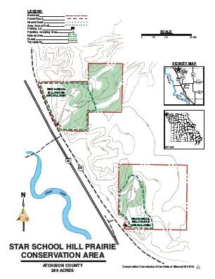
About This AreaThe Conservation Department purchased 129 acres in 1989. In 1994, the Department added a 160 acre tract a short distance south of the original purchase.Star School Hill Prairie Conservation Area is characterized by rugged loess hills adjacent to the Missouri River floodplain. These windblown hills were formed by prevailing westerly winds during the glacial period. Loess deposits over bedrock sometimes reach 150 to 200 feet in depth. Loess soil drains very rapidly, creating hot, dry prairie habitat that supports unique communities. Loess hill prairie communities are endangered in Missouri, and the small remnants that still exist are threatened by overgrazing, woody invasion, erosion, and homesite development.The 12-acre Loess Hill Prairie is primarily managed by the use of controlled burning and selective cutting to control the invading woody species. The prairie provides habitat for 12 plant species and two animal species on the Missouri Species of Conservation Concern Checklist.The remainder of the area is managed for a wide range of game and non-game wildlife species. The area is available to the public for a variety of outdoor activities compatible with resource management.Star School Hill Prairie Natural Area features dry prairies on ridge tops which can be seen from the parking lots on both the north and the south tracts. These ridge tops offer expansive views of the Missouri River valley - on a clear day, four states (Missouri, Iowa, Nebraska, and Kansas) can be seen. Over a dozen prairie plants are Missouri species of conservation concern and are more typically found in the Great Plains 100 miles or more to the west.Erosion of mounds of wind blown loess soil well over 100 feet deep has created a steep and rugged landscape.Lewis and Clark camped in this vicinity on their journey up the Missouri River.