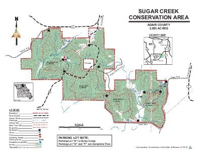
Driving DirectionsFrom Kirksville, take Highway 11 west 4 miles, then Route N south 0.25 mile to the area.
HighlightsThe area is mainly forest with old fields and cropland. Facilities/features: hiking trail, designated multi-use trail (permit required for groups of 10 or more riders), and intermittent streams (Sugar Creek, Elm Creek).
About This AreaSugar Creek Conservation Area is in Adair County, four miles southwest of Kirksville. The Conservation Department acquired the original 72 acres of this area as a forest fire lookout tower site, but the tower was never built. Known then as "Kirksville Woods," this small area was combined with a 2,536-acre tract, purchased in 1974, to create Sugar Creek Conservation Area.The area is primarily forested, with a few open fields on ridges and along Sugar Creek. Both Sugar Creek and Elm Creek run through the area.Around the turn of the century, thousands of acres of the region's forests, including this area, were cleared to meet the great demand for mine props and timbers for the coal mining industry in northeast Missouri. Subsequent tree sprouting here was once contained by grazing goats, and part of the area was once known as the "goat ranch." Most of the area was then allowed to revert back to trees, which accounts for the large, continuous stand of similar-age trees.Wildlife management practices include crop fields to serve as food sources for animals and harvesting timber, which provides wildlife improved forage and cover. White-tailed deer and wild turkey are abundant on the area, as are numerous songbirds and a variety of mammals.