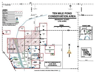
Driving DirectionsFrom East Prairie, take Highway 80 east, then take gravel County Road 515 south 5 miles to the tee. At the tee go left 300 yards to headquarters on the right.
HighlightsThis area is predominantly cropland and wetlands, managed for dove, shorebirds, wading birds, and waterfowl.
About This AreaThis 3,755-acre area was once a lowland hardwood forest intermingled with cypress sloughs. Most of the area flooded seasonally and was an important habitat for wintering waterfowl, furbearers, eagles, and other wildlife species.Management of the area began in 1982 and is aimed at reestablishing wetland habitat, which was lost when the land was drained and converted to agricultural use. Over 1,000 acres of this wetland habitat is managed through the manipulation of water levels to provide high quality natural foods, such as millets, smartweed, sprangletop, sedges, and invertebrates. These food resources are highly sought after by migrating and wintering waterfowl, shorebirds, and other wetland wildlife species. Row crops and green browse are grown on the area to provide nutritious food for geese and field-feeding species of ducks.Wetland development has included the construction of interior levees, wells, pumps, and water control structures.Duck and goose hunting and viewing waterfowl are the most popular outdoor activities on the area. Bald eagles are common on the area from late fall through early spring.Visitors should use extreme caution while boating or wading, because deep water and hazardous conditions are possible when the area is flooded.