Driving DirectionsFrom Montreal, take Route E northeast 3 miles, then Route A east 1.50 miles.
HighlightsThis area is mostly forest and grassland. Facilities/features: picnic area, permanent stream (Wet Glaize Creek).
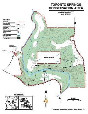
About This AreaToronto Springs Conservation Area is located in Camden County, five miles east of Montreal on Route E, then one mile east on Route A, which forms most of the southern boundary of the area.The conservation area was established in 1986 with an initial acquisition of 532 acres. Two additional land purchases have expanded the area to its present size and have improved public access to a 2.5-mile section of Wet Glaize Creek.Toronto Springs, a multi-outlet source, has a flow of two to four million gallons per day.In the late 1850s, a mill was built near the junction of Wet Glaize Creek and the spring branch. During its heyday, the Toronto Springs Mill was reported to have served locally produced cheese and beer to patrons waiting for their grain to be milled. It also served as a community center, where elections and church services were held. The only remaining clue to the exact location of this important mill are the springs.The area offers a 10-car parking lot off Route A for canoe access to Wet Glaize Creek. There are three other parking areas, one on Route A and the other two are off Route C which provide access to ridge top forest areas. Toilet facilities or approved water are not provided.