Driving DirectionsFrom I-49/Highway 71 at Archie, take Route A west 5 miles, then Route W north 4.50 miles to the area.
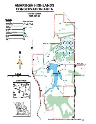
HighlightsThis area contains grassland, wetlands (95 acres), forest/woodlands, cropland and old fields. Facilities/features: boat ramp, fishing jetty, Amarugia Lake (45 acres), and permanent streams (South Grand River and South Fork creek).
About This AreaAmarugia Highlands Conservation Area is located in a region once known as "The Kingdom of Amarugia," where a group of people formed their own government and had their own society. A series of prominent hills in this region is still known as the Amarugia Highlands. The hills in the southern portion of the Conservation Area are part of these highlands.The 1,081-acre area was purchased by the Missouri Department of Conservation in 1983. One of its main attractions is the man-made 45-acre Amarugia Lake, which was completed in 1987. The lake was stocked in 1988 with channel catfish, largemouth bass and bluegill. The area also has numerous small ponds and a short stretch of the South Grand River.Terrain varies from bottomland crop fields and old fields to rolling upland grasslands and woodlands. Crop fields are managed for a variety of game and non-game wildlife species. Haying and controlled burning are used to maintain plant diversity in open areas. Habitat plantings include trees, shrubs and native grasses.Disabled accessible fishing, parking and toilets are available on the area. A boat ramp is located on the lake.