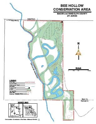
Driving DirectionsFrom Macon, take Highway 63 south 8 miles, then Jackpot Road west 2 miles.
HighlightsThis area contains forest, cropland, and old fields. Facilities/features: walk-in access to the East Fork of the Little Chariton River.
About This AreaIn 1986, the Missouri Department of Conservation acquired the property in a land transfer with the Farmers Home Administration.This 271-acre area contains 170 acres of forest, 52 acres of cropland, 22 acres of wetlands, and 13 acres of old fields. Walk-in access to the East Fork of the Little Chariton River is available. One mile of stream frontage lies along the western boundary of the area. The eastern half of the area is spoil ridges left after coal mining. The western half of the area consists of low lying river bottom fields and beaver ponds.The wetland pools and oxbow sloughs on the western half of the area attract a variety of nesting and migrating waterfowl.Management of the area includes farming, moist soil wetland management, timber harvest, and controlled burns to improve wildlife habitat and increase species diversity.Bee Hollow Conservation Area is managed primarily for waterfowl, deer, and turkey. The wetland pools are managed to provide fall and spring migration habitat while providing habitat for reptiles and amphibians.