Driving DirectionsFrom Ironton, take Highway 21 north 8 miles, then Route U northeast to the area.
HighlightsThis is a forest area.
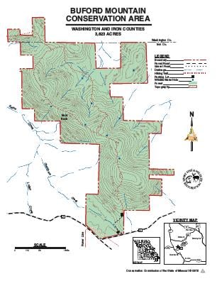
About This AreaBuford Mountain Conservation Area, located east of beautiful Belleview Valley, was purchased by the Missouri Department of Conservation from the Nature Conservancy in 1979. The area was named after its settlement in 1812 by William Buford, who acquired the land through a Spanish Land Grant. Today, Buford Mountain covers 3,824 acres.In the mid- to late-1800s, the charcoal industry flourished in the Belleview-Arcadia Valley. Old charcoal kilns still remain over the entire mountain.The highest peak of the mountain is 1,740 feet above sea level. With most of the mountain hardened by granite known as Rhyolite, the area yields little permanent water. Limestone stream beds mark the base of the mountain. Several wet weather springs can be found over the area; these are usually dry, however, during summer.The area's most outstanding feature is its glades, ranging in size from less than one acre to over 10 acres. These glades provide many scenic views and excellent opportunities to observe glade plants and animals. Because of the sensitive nature of the plant and animal communities and very thin soils common to the glades, activity on the glades is restricted to walking only.Buford Mountain is home to wildlife species common to Missouri. This is a favored hunting area for turkey hunters, and some deer hunting occurs as well.