Driving DirectionsFrom Brounaugh, take Highway 43 south 2.50 miles to Zodiac Road, then east 1 mile to the area.
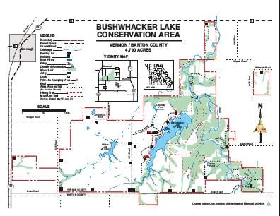
HighlightsThis area contains prairie, forest, old fields, cropland, grassland and savanna. Facilities/features: boat ramp, primitive camping, three fishing jetties, fishing dock, Bushwhacker, and Willow lakes (196 acres total), and a permanent stream (Drywood Creek).
About This AreaDuring the Civil War, Kansas Jayhawkers ambushed local residents believed to be Confederate sympathizers. In retaliation, those men, known as bushwhackers, banded together and started their own guerilla war against the Union. The guerilla warfare soon spilled over into Missouri, and some fierce fighting took place along Little Dry Wood Creek.Bushwhacker is an appropriate name for the conservation area that now covers 4,790 acres along the Vernon and Barton county lines. Little Dry Wood Creek runs through the eastern side of the area.Historically, nearly the whole area was prairie, with timber only along Little Dry Wood Creek and its drainages. Before it became public land, much of the original prairie had been plowed and put into crops, or disced and seeded to fescue. The more than 1,400 acres of prairie remaining today are being restored through controlled grazing, herbicide treatment, and burning. About 120 acres of native hay meadows also remain and harbor the same plant communities that buffalo once grazed. Other wildlife, such as quail, rabbits, and deer, are common. Each fall and spring, hundreds of waterfowl use the area's lakes and ponds.One of the drainages was dammed in 1982 to make 157-acre Bushwhacker Lake. This lake, along with a smaller lake and numerous ponds on the area, has been renovated and stocked with bass, bluegill, and channel catfish.During your visit to Bushwhacker Lake Conservation Area, you may observe various wildlife management, research, and soil conservation activities. Sharecrop agreements with local farmers help provide food for wildlife. Trees and shrubs are planted along the boundaries, and clumps of shrubs will be planted in the open fields to provide cover for quail and other wildlife. Native warm-season grasses and prairie forbs, wheat and lespedeza are being planted in strips. Any physical disturbance is only temporary.