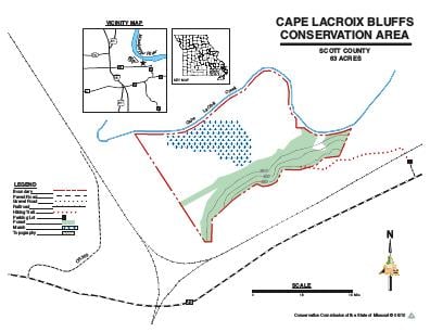
Driving DirectionsFrom Cape Girardeau, take Exit 91 on I-55, then take Route AB (Nash Road) east almost 3 miles. The parking area for Cape LaCroix Bluffs CA is located just before the intersection of Route K and Route AB (Nash Road).
HighlightsCape LaCroix Bluffs CA was purchased to provide habitat for the state endangered Spring Cavefish. Buttonbush shrub-swamp wetland communities provide habitats for waterfowl, shorebirds, wading birds; amphibians and reptiles; and spawning Big River fishes. Remnant wetland communities are present due to the footprint of historic Cape LaCroix Creek which meandered through the area before the Diversion Channel was emplaced. This is a unique area that experiences regular seasonal flooding when the Mississippi River reaches flood stages.Limestone bluffs, on the southern extent of the area, overlook the Mississippi River and the remnant wetlands of Cape LaCroix Creek.
About This AreaCape LaCroix Bluffs CA is a 63.21 acre area situated in northern Scott County in close proximity to the Diversion Channel and the Southeast Missouri Port Authority. Located off of Nash Road, Cape LaCroix Bluffs supports one of the rarest fishes in Missouri, the spring cavefish. Spring cavefish spend the majority of their lives underground in springs and aquatic caves. Spring cavefish is also known from just across the River in the Illinois Ozarks. Spring cavefish occupies similar habitats there. In fact, the geography that the spring cavefish occupies in Missouri, the Benton Hills, is closely associated with the Illinois Ozarks. Owing the close association to a relatively recent shift in the Mississippi River's course.At Cape LaCroix Bluffs CA visitors can observe the old channel of the Mississippi River (the channel that use to travel west towards Mingo National Wildlife Refuge) and the present channel that flows through Thebes Gap. Flooding episodes on the Mississippi River, as glaciers melted across North America, led to a major (catastrophic) shift in the direction of flow of the Mississippi River. Floods that breached Thebes Gap allowed the Mississippi River to occupy its present channel and abandon the historic channel that traveled along the western extent of Southeast Missouri's bootheel.Cape LaCroix Bluffs supports natural wetlands, limestone bluffs, and beech mesophytic forests unique to eastern Missouri.