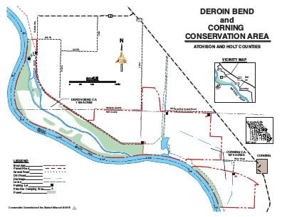
Driving DirectionsFrom Corning, take Highway 111 northwest 5 miles, then Route Z west 2.50 miles, then Golden Avenue south 0.75 mile.
HighlightsThis area is primarily old fields, forest, and wetlands. Facilities/features: primitive camping, Missouri River chute, and a permanent stream (Missouri River).
About This AreaThe Conservation Department purchased this area along the Missouri River after the flood of 1993. The area was acquired to preserve unique wetland and fisheries habitats, and to restore 3.3 miles of the old Missouri River chute, and the 400-acre island.The area is named after a nearby bend in the river that was originally named after Joseph Deroin, who settled near this area in the 1840's and established the St. Deroin trading post on the bank of the river. The trading post was abandoned in the early 1920's.This area is managed for a wide variety of game and non-game species of fish and wildlife. Rich bottomland soils here produce a wide variety of wetland vegetation and bottomland timber, which are supplemented by plantings of warm-season grasses. Management practices include reforestation, prescribed burning and opportunistic management of wetlands.