Driving DirectionsFrom Advance, take Route C west 7 miles, take County Road 614 north 1 mile to Greenbrier, then Route W north 3 miles, and County Road 604 east for 0.75 mile then turn right (south) for 0.25 mile. The road dead ends at a private drive where the entrance to the area is on the left.
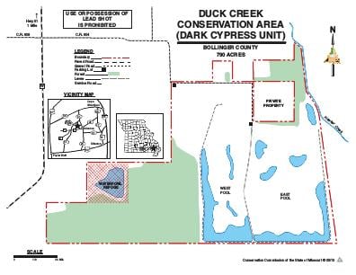
HighlightsThis area consists of restored wetlands, bottomland forest and swamp communities. Wetlands were restored through the Wetland Reserve Program (WRP) in cooperation with the Natural Resources Conservation Service (NRCS).There is an elevated road crossing Dark Cypress which provides access to private property to the south and divides the area into two large main pools with open marsh and reforested areas.Each pool is bounded by low, broad levees and contains many manmade topographical features such as habitat mounds, meandering sloughs and shallow depressions. These features are designed to capture and retain receding flood waters from the Castor River Diversion Channel and provide diverse wetland habitats ranging from semi-permanent pools with exposed mud flats to higher sites which occasionaly are flooded for a few days at a time.
About This AreaDuck Creek Conservation Area is now comprised of three units. In addition to the main area on Highway 51, there are two additional units. The Dark Cypress Swamp Unit of Duck Creek Conservation Area occupies the basin where the vast, original Dark Cypress Swamp existed at the time of settlement, so this name has been applied to this parcel. The area formerly named Dark Cypress Swamp, southwest of this Unit along Route C, is now the Greenbrier Unit of Duck Creek.Dark Cypress Swamp is in southern Bollinger County where the Ozark foothills meet the level floodplain formed when the ancient Mississippi River flowed through the Advance Lowlands.Much of the area was forested as recently as 40 years ago. Subsequent drainage and conversion to farmland left only the wettest land uncut and intact.In 2005, the Department purchased the 790-acre area from The Little River Drainage District. It had already been enrolled in WRP by the Drainage District, so the restoration process began shortly after MDC assumed ownership.Crader Ditch and Hawker Creek (near the east and south property lines), and the nearby Diversion Channel all influence area vegetation through period flooding.Dark Cypress Swamp supports a variety of migratory birds, including waterfowl as well as resident swamp and cottontail rabbits, otter, raccoon, opossum, bobcat, and squirrels.