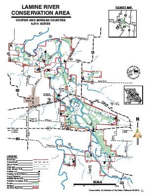
Driving DirectionsLamine River Conservation Area has five tracts. From Otterville, take Route A east 1 mile. Highway 50 at the Lamine River provides access. Please see map for additional access.
HighlightsThis 6,017 acre area has a unique combination of river, floodplain, rolling uplands, and steep river bluffs. The Lamine River is a signature feature of the area, meandering through bottomlands of forest, cropfields, oldfields, and small wetlands. Uplands have woodland tracts, and a mix of oldfields and grassland areas often divided by brushy draws and scattered ponds.Facilities/Features: boat ramp, primitive camping, nine fishing lakes with 19 acres of fishable water, three miles of intermittent streams, and 12 miles of Lamine River.
About This AreaLamine River Conservation Area is in Cooper and Morgan counties, east of Otterville and easily accessed by Highway 50 and Route A, which bisect the area.The Lamine River, formed by the confluence of Richland and Flat creeks, at the south end of the area, was first named Riviere a la Mine, or River of the Mine; by a prospecting party under Phillip Renault, Director-General of the French colonies in America, as early as 1723.During the Civil War, La Mine crossing was a location where the railroad bridge crossed the river just east of Otterville. The railroad and bridge was of strategic importance for Union Supplies and in 1861 Union Troops dug entrenchments to protect the bridge crossing. A Department of Natural Resources kiosk located on the area immediately west of the Lamine River bridge displays the historical account of the Civil War events and Union entrenchments.The Lamine River Area is located where an interesting combination of land types merge. The rolling farm ground east and west of the area were historically prairies separated by the Lamine River valley. A more rugged Ozark, savanna woodland land type is found on the south end of the area, while a forest hills land type occurs as one moves to the north end of the area. The Lamine River is a transition stream displaying characteristics of both a prairie/farmland stream (Flat Creek) and an Ozark type gravel bottom pool/riffle stream (Richland Creek).The landscape variety lends variety in management. Area users can expect to see prescribed burning, discing, chainsaw edgefeathering, brushpile construction, fescue conversion, and control of undesirable and invasive plants as part of the area management. Agricultural practices of rowcrop farming, planting foodplots, haying, overseeding legumes, and planting warmseason grasses, native wildflowers or forbs are used to create and manipulate desirable habitat and wildlife food during the year.The Lamine River area offers great opportunity for seasonal viewing of migrating birds. The rivers, streams and ponds offer the leisure of bank fishing and wildlife viewing, or wade fishing, float fishing, or canoeing for the more ambitious. Hunting of rabbits, squirrels, quail, woodcock, waterfowl, turkey and deer is a popular pastime. But just spending time outdoors is as good excuse as any to visit the Lamine River Conservation Area.