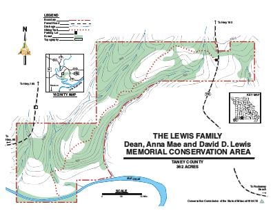
Driving DirectionsFrom Highway 465/Highway 65/Route F intersection, on the north side of Branson, take Route F east 3.40 miles, then Highway 160 southeast 0.25 mile, then Highway 176 south 0.67 mile to the parking lot on the west side of Highway 176.
HighlightsBull Creek runs through the southern portion of the area. The Conservation Area is a mix of forest, woodland, savanna, grassland, and glades.
About This AreaThis Conservation Area was generously donated by the late David D. Lewis in 2012. It is located a short distance northeast of the City of Branson. Bull Creek runs through the southern portion of the area for a length of approximately one-half mile. Habitat communities on the area are diverse with a mix of upland and bottomland forest, as well as woodlands, savannas, grasslands, and glades. A 40 acre portion of this area, on the east side, is within the Village of Merriam Woods.