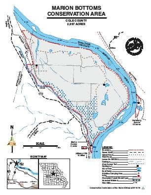
Driving DirectionsFrom Marion, take Highway 179 north 2.50 miles, take Moniteau Creek Road east to the area.
HighlightsThis area contains forest, wetlands, and old fields. Facilities/features: primitive camping, fishable lakes, and ponds (75 acres total), and two permanent streams (Moniteau Creek, Missouri River).
About This AreaMarion Bottoms Conservation Area, in Cole County, is located two miles north of Marion, MO on Moniteau Creek road off of Highway 179.The 2,997-acre area was purchased in 1996 and is surrounded by the Missouri River on the north, east, and south boundaries, providing six miles of river frontage. The site was acquired by the Conservation Department in 1996, bought in part with funds provided by the federal government after the 1993 flood to negotiate purchase of flood prone land in order to lessen the chance and severity of future floods.The area includes riparian and successional forests, old fields, marshes, several blue holes, and several hundred acres of wetland that include areas of open water, and seasonly flooded vegetation, and flooded forest. The wetlands, blue holes, and riverine habitats provide valuable habitat for fish, waterfowl, shorebirds, and amphibians. As successional forests, dominated by cottonwood and willow, develop into mature, bottomland forests, habitat for turkey and other small game will increase.Area management has emphasized restoration of chutes to allow the Missouri River access to parts of the area formerly protected by levees. This will provide additional spawning and feeding areas for fish, and wetland habitat for wildlife. Management has also emphasized seasonal wetlands to benefit waterfowl, furbearers, reptiles, and amphibians.