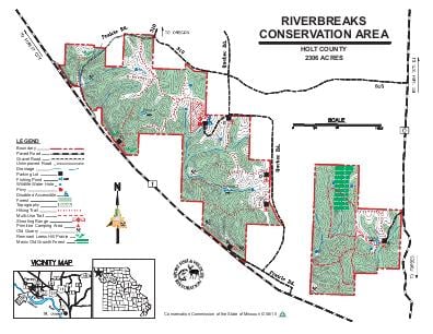
Driving DirectionsArea consists of two tracts.To the east tract: from Oregon, take Highway 59 east, then Route O south 3.25 miles to the highway sign.To reach the west tract: continue south on Route O, then take Route T west 1.50 miles to the area.
HighlightsThis area is more than half forest with grassland, old fields, cropland, and prairie. Facilities/features: primitive camping, three fishing ponds, single projectile firearms range, and three permanent streams (Whales Creek, Schlotz Branch, and Forbes Creek).
About This AreaRiverbreaks Conservation Area is located in southern portion of Holt County. The area is in two adjacent tracts approximalety four miles southeast of the town of Oregon, off of Route O and Route T. This 2,307-acre area is nestled among the loess hill river bluffs overlooking the Missouri River floodplain.Prior to settlement, Riverbreaks was likely covered by a mix of forest and grasslands. Settlers cleared, cropped or allowed animals to graze portions of the land.The area is continuing to change and currently is a diverse combination of forest, grasslands (both new and old), and cropfields. Native loess hill prairies remanants still exists in small pockets. The forest consists primarily of upland oak hickory mixed hardwoods with scattered pockets of bottomland hardwoods.Three permanent named creeks wind through the area. In addition there are three small fishable ponds which have been stocked with bluegill, largemouth bass, and channel catfish. Several other small fishless wildlife water holes are scattered throughout the area.The soils in the area consists of very deep (in some locations as deep as 280 feet) wind-blown silt, called loess, covering a limestone base.Several abandoned limestone quarries can be found along the south side of the area.Riverbreaks Conservation Area is managed for a variety of uses, including outdoor recreation and education, wildlife habitat, productive sustainable forests and soil and water protection. Area management practices include wildlife watering holes, planted wildlife food sources, establishing and managing (often with controlled fire) native warm season grasslands,and harvesting timber for wildlife habitat and sustainable forests.An unstaffed single projectile target shooting range is located in the center of the west tract off of Quebec Road (gravel).