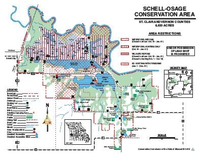
Driving DirectionsFrom El Dorado Springs, take Highway 54 west 6 miles, then Route AA north 12 miles, then Route RA east 1.50 miles (last 0.50 mile is gravel), then 2950 Road south 0.25 mile to the area.
HighlightsThis area provides waterfowl hunting opportunity for up to 43 parties of hunters in the wetland units, including 25 blinds (two are disabled-accessible) and 18 designated wade-and-shoot positions (two of which are field opportunities). The area also contains fishable lakes and ponds totaling over 900 acres, in addition to opportunity on the Osage River Arm of Truman Reservoir. There is also a boat ramp and primitive campground on each lake.
About This AreaSchell-Osage Conservation Area and the Osage River, which forms the area's north boundary, derive their names from the Osage Indians that once inhabited the area. Initially purchased in 1957, development of the wetland units and water supply lakes was completed in 1962 and opened to waterfowl hunting in 1964. The Harry S. Truman Dam and Reservoir was completed in 1979, which affected flood frequency and duration of the Osage River and floodplain, including portions of Schell-Osage. The area features a unique combination of habitats including roughly 1,900 acres of bottomland and upland forest, 1,800 acres of cropland, 1,700 acres of old fields, and over 900 acres of lakes and ponds. Also, Little Headwaters, Little Gem, Little Stony Point, Little Savanna, and Little Sandy prairies combine to make up over 40 acres of remnant native prairie, which have been augmented with an additional 170 acres of restored grasslands. The nearly 1,800 acres of seasonally flooded wetlands provide habitat for a wide variety of waterfowl, shore birds, wading birds, and other wetland dependent species, which makes this area popular for both waterfowl hunters and birders.