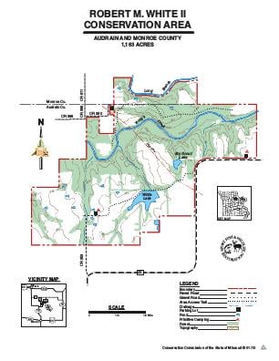
Driving DirectionsFrom Mexico, take Highway 15 north 8 miles, then Route Z east 2 miles, and Route ZZ east 2 miles.
HighlightsThe area is largely forest with cropland, old fields, grassland, and prairie. Facilities/features: two permanent streams and two lakes (18 acres total).
About This AreaRobert M. White Conservation Area is in both Audrain and Monroe counties, approximately 11 miles north of Mexico, Missouri and 16 miles southeast of Paris. The area is less than 20 miles south of Clarence Cannon Reservoir.This 1,163-acre area is named for Robert M. White II who donated the land for use as a wildlife area. Mr. White, former owner of the Mexico Ledger, worked diligently with the U.S. Soil Conservation Service and the Conservation Department to protect the soil and develop wildlife habitat.Approximately 460 acres of the area are timbered. The remainder of the property is in row crops, warm-season grasses, or fruiting shrubs.The area includes numerous ponds and a 15-acre fishing lake. Robert M. White conservation Area has no facilities, but hunting, fishing, hiking, and camping are encouraged. The lake access road is open to vehicles May 10th to August 31st, dry weather use only.Management efforts, including prescribed burns, discing, and rowcropping, are designed to provide habitat for wildlife.