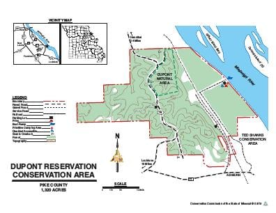
Driving DirectionsFrom Hannibal, take Highway 79 south 17 miles, then Route TT east, then north onto gravel road at Ted Shanks Conservation Area entrance, 1.70 miles to ramp.
HighlightsA predominantly forested area offering spectacular views of the Mississippi River floodplain off of the Little Dixie National Scenic Byway (Highway 79). There is an 80-acre mixed upland hardwood forest Natural Area. The area borders the Mississippi River and offers a boat ramp, campground, and River access and is an excellent place to view fall color.
About This AreaFrom 1892 through 1932 a dynamite factory on this site provided explosives for lead, zinc and coal mines in the tri-state area and nitroglycerin for use in Oklahoma oil fields. Separate facilities were built in different valleys in this rough terrain to lessen the chance of a chain reaction explosion, should any one of the buildings explode. E.I. DuPont de Nemours and Company donated 1,122.8 acres to the Conservation Commission in 1938. Subsequent land purchases have increased the size of this area to its present 1,320 acres. The area consists of 975 acres of upland timber, 310 acres of bottomland timber and 35 acres of old fields and grassland. It also contains plantations of walnut, cottonwood, tulip poplar, pine and bald cypress trees. A boat access and primitive campground are located along a portion of 1.5 miles of Mississippi River frontage. DuPont Forest Natural Area is found east of Highway 79. This 80-acre tract is a mixed upland hardwood forest and small limestone glade, lying within the Lincoln Hills Section of the Glaciated Plains Natural Division. Basswood, northern red oak, white oak, chinquapin oak and sugar maple are common overstory trees.