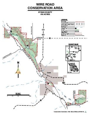
Driving DirectionsWire Road Conservation Area consists of several tracts. To get to the largest tract, located northwest of Crane, take Highway 413 north 1.10 miles, then Old Wire Road west 1 mile to a parking lot on the north side of the road. A small tract, with a parking lot, is located in the City of Crane on the east side of Highway 413, just south of Crane Creek on the opposite side of the creek from the city ball park. Another tract is located 1 mile southeast of Crane. From the junction of Highway 413 and Swinging Bridge Road, take Swinging Bridge Road east 0.40 miles, then Grisham Ford Road north 0.15 mile across Crane Creek to a parking lot on the east side of the road.
HighlightsThis area is made up of forest, bottomland plantations, old fields and native grass fields. Facilities/features: permanent stream (Crane Creek).
About This AreaWire Road Conservation Area is a 818-acre tract located in northwestern Stone County. The area was purchased in 1983 and encompasses 3.7 miles of Crane Creek.The area was named Wire Road because it is crossed by a pre-Civil War road that followed a telegraph line between Rolla and Fort Smith, AR.A field at the junction of Crane Creek and the original Wire Road was an important encampment during the Civil War. It was occupied by several thousand Confederate troops before and after the Battle of Wilson's Creek.A fork of the Cherokee Trail of Tears also passed through this area, as well as the famous Butterfield Stage Route. A major trail of some sort is thought to have existed on this area since Europeans first traveled in Stone County.Wire Road Conservation Area consists primarily of typical upland oak-hickory forest and bottomland hardwoods, including sycamore, bur oak, northern red oak, and black walnut.Before Department ownership, the bottom fields of the conservation area were farmed and grazed. Some existing stands of fescue have been converted to annuals and native grasses.The riparian zone along Crane Creek and bottomland fields are being replanted with trees to protect the waterway. Over 30,000 trees have been planted.