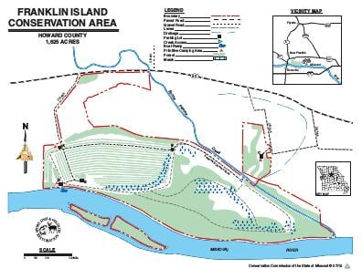
Driving DirectionsFrom New Franklin, take Highway 40 east 2 miles.
HighlightsThis area contains forest, old fields, cropland and wetlands. There are two permanent streams (Bonne Femme Creek, Missouri River).
About This AreaFranklin Island Conservation Area is in Howard County, two miles north of Boonville on Highway 40. The area contains 1,625 acres, including bottomland timber in the Missouri River, Bonne Femme Creek corridors, and permanent grasses on the levees and grain fields, which are left unharvested to provide food for wildlife.The Missouri River once cut a channel on the area's north boundary, and the land was surrounded by water. In 1952, the remnant chute was closed permanently by a flood control levee. The Conservation Department purchased the land in 1978.The Missouri River conveyed both French trappers, who provided the name of Bonne Femme Creek, and American explorers, including Lewis and Clark, who camped near the creek's mouth. The first early settlers to come up the river were wealthy tobacco farmers from Virginia and Kentucky. Soon, agricultural crops were being shipped from the ports of Franklin, Glasgow, and Rocheport.Farming increased in the bottomlands as the river was narrowed and straightened in the early part of the century. By the 1950s, continued narrowing and straightening and the construction of flood protection levees combined to provide relief from recurrent flooding.Current management goals are to restore much of the area to bottomland timber by allowing natural succession and supplementing plantings of selected native tree species. About 150 acres of the area remain in crop production; a portion of which is left unharvested for wildlife benefit.